![](/images/other/stat-length.png)
![Trail Winter sports Les Angles - Capcir_Angles-Bouillouses - Photo](https://media.geolcdn.com/t/1900/400/ext.pjpeg?maxdim=2&url=https%3A%2F%2Fstatic1.geolcdn.com%2Fsiteimages%2Fupload%2Ffiles%2F1524743153ski.jpg)
Capcir_Angles-Bouillouses
PaulNord
User
![Length](/images/other/stat-length.png)
Length
9.4 km
![Max alt](https://static1.geolcdn.com/siteimages/upload/files/1508320355ic_sort_altitude_max_24dp.png)
Max alt
2190 m
![Uphill gradient](https://static1.geolcdn.com/siteimages/upload/files/1508320355ic_sort_den_pos_24dp.png)
Uphill gradient
479 m
![Km-Effort](/images/other/stat-length.png)
Km-Effort
15.1 km
![Min alt](https://static1.geolcdn.com/siteimages/upload/files/1508320355ic_sort_altitude_min_24dp.png)
Min alt
1795 m
![Downhill gradient](https://static1.geolcdn.com/siteimages/upload/files/1508320355ic_sort_den_neg_24dp.png)
Downhill gradient
268 m
![Boucle](https://static1.geolcdn.com/siteimages/upload/files/16400158638029165_repeat_loop_refresh_sync_direction_icon.png)
Boucle
No
Creation date :
2015-02-02 00:00:00.0
Updated on :
2015-02-02 00:00:00.0
![Winter sports](https://static1.geolcdn.com/sitytour/trail-icons/500.png)
3h00
Difficulty : Easy
![Scan this QR Code to open this trail in the SityTrail application](https://capi.geolives.com/qq0zvz2zws4bq2lad0pu/sitytour/trails/382604/qr.png?size=200)
FREE GPS app for hiking
About
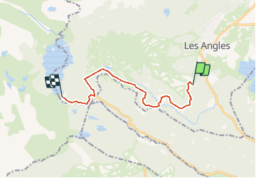
Trail Winter sports of 9.4 km to be discovered at Occitania, Pyrénées-Orientales, Les Angles. This trail is proposed by PaulNord.
Description
Départ : Parking Pla del Mir
Arrivée : Ref. Bouillouses
Altitude max 2193
Altitude min 1800
Dénivelé : 507
Dénivelé - : 301
Positioning
Country:
France
Region :
Occitania
Department/Province :
Pyrénées-Orientales
Municipality :
Les Angles
Location:
Unknown
Start:(Dec)
Start:(UTM)
423319 ; 4712741 (31T) N.
Comments
Trails nearby
![Trail Walking Font-Romeu-Odeillo-Via - Coll del Pam lac des Bouillouses - Photo](https://media.geolcdn.com/t/375/260/ext.jpg?maxdim=2&url=https%3A%2F%2Fservices.sitytrail.com%2FGeolivesWS%2FDownloadMedia.ashx%3FTrailID%3D802013%26Media%3Dfix__20170803141713.jpg)
![Walking Walking](https://static1.geolcdn.com/sitytour/trail-icons/101.png)
Coll del Pam lac des Bouillouses
Walking
Medium
(2)
Font-Romeu-Odeillo-Via,
Occitania,
Pyrénées-Orientales,
France
![](/images/other/stat-length.png)
13.3 km | 19.3 km-effort
4h 10min
![](https://static1.geolcdn.com/siteimages/upload/files/16400158638029165_repeat_loop_refresh_sync_direction_icon.png)
Yes
![Trail Snowshoes Les Angles - Lac d Aude -Refuge Bernardi les Angles - Photo](https://media.geolcdn.com/t/375/260/ext.jpg?maxdim=2&url=https%3A%2F%2Fservices.sitytrail.com%2FGeolivesWS%2FDownloadMedia.ashx%3FTrailID%3D400729%26Media%3Dfix__20150327134406.jpg)
![Snowshoes Snowshoes](https://static1.geolcdn.com/sitytour/trail-icons/504.png)
Lac d Aude -Refuge Bernardi les Angles
Snowshoes
Medium
(1)
Les Angles,
Occitania,
Pyrénées-Orientales,
France
![](/images/other/stat-length.png)
13.9 km | 19.1 km-effort
5h 44min
![](https://static1.geolcdn.com/siteimages/upload/files/16400158638029165_repeat_loop_refresh_sync_direction_icon.png)
Yes
![Trail Walking Les Angles - lac d'Aude - Photo](https://media.geolcdn.com/t/375/260/ext.jpg?maxdim=2&url=https%3A%2F%2Fmedia.geolcdn.com%2Ff%2Fdc6c3cf8-db43-4620-818b-ca96b3366767.jpg)
![Walking Walking](https://static1.geolcdn.com/sitytour/trail-icons/101.png)
lac d'Aude
Walking
Medium
Les Angles,
Occitania,
Pyrénées-Orientales,
France
![](/images/other/stat-length.png)
13.8 km | 0 m-effort
5h 57min
![](https://static1.geolcdn.com/siteimages/upload/files/16400158638029165_repeat_loop_refresh_sync_direction_icon.png)
Yes
![Trail Walking Les Angles - Lac d'Aude en boucle - Photo](https://media.geolcdn.com/t/375/260/ext.jpg?maxdim=2&url=https%3A%2F%2Fmedia.geolcdn.com%2Ff%2Fbb545742-b218-4a2b-8572-21d45496180e.jpg)
![Walking Walking](https://static1.geolcdn.com/sitytour/trail-icons/101.png)
Lac d'Aude en boucle
Walking
Medium
Les Angles,
Occitania,
Pyrénées-Orientales,
France
![](/images/other/stat-length.png)
13.8 km | 19.9 km-effort
6h 8min
![](https://static1.geolcdn.com/siteimages/upload/files/16400158638029165_repeat_loop_refresh_sync_direction_icon.png)
Yes
![Trail Walking Les Angles - les Angles - Photo](https://media.geolcdn.com/t/375/260/ext.jpg?maxdim=2&url=https%3A%2F%2Fmedia.geolcdn.com%2Ff%2Fa1624f8b-9696-405f-8c28-1fd4c2634375.jpg)
![Walking Walking](https://static1.geolcdn.com/sitytour/trail-icons/101.png)
les Angles
Walking
Difficult
Les Angles,
Occitania,
Pyrénées-Orientales,
France
![](/images/other/stat-length.png)
14.5 km | 20 km-effort
4h 58min
![](https://static1.geolcdn.com/siteimages/upload/files/16400158638029165_repeat_loop_refresh_sync_direction_icon.png)
No
![Trail Walking La Llagonne - llagonne - Calvet - Photo](https://media.geolcdn.com/t/375/260/ext.jpg?maxdim=2&url=https%3A%2F%2Fstatic1.geolcdn.com%2Fsiteimages%2Fupload%2Ffiles%2F1553511878bg_sport_marche.png)
![Walking Walking](https://static1.geolcdn.com/sitytour/trail-icons/101.png)
llagonne - Calvet
Walking
Medium
(2)
La Llagonne,
Occitania,
Pyrénées-Orientales,
France
![](/images/other/stat-length.png)
11.2 km | 14.2 km-effort
3h 0min
![](https://static1.geolcdn.com/siteimages/upload/files/16400158638029165_repeat_loop_refresh_sync_direction_icon.png)
No
![Trail Nordic walking Font-Romeu-Odeillo-Via - mauroux - Photo](https://media.geolcdn.com/t/375/260/ext.jpg?maxdim=2&url=https%3A%2F%2Fstatic1.geolcdn.com%2Fsiteimages%2Fupload%2Ffiles%2F1545311037marcheuse_200dpi.jpg)
![Nordic walking Nordic walking](https://static1.geolcdn.com/sitytour/trail-icons/102.png)
mauroux
Nordic walking
Medium
(2)
Font-Romeu-Odeillo-Via,
Occitania,
Pyrénées-Orientales,
France
![](/images/other/stat-length.png)
11.2 km | 14.7 km-effort
1h 20min
![](https://static1.geolcdn.com/siteimages/upload/files/16400158638029165_repeat_loop_refresh_sync_direction_icon.png)
Yes
![Trail Snowshoes Les Angles - lac d aude - Photo](https://media.geolcdn.com/t/375/260/ext.jpg?maxdim=2&url=https%3A%2F%2Fstatic1.geolcdn.com%2Fsiteimages%2Fupload%2Ffiles%2F1524743153raquette.jpg)
![Snowshoes Snowshoes](https://static1.geolcdn.com/sitytour/trail-icons/504.png)
lac d aude
Snowshoes
Very easy
(2)
Les Angles,
Occitania,
Pyrénées-Orientales,
France
![](/images/other/stat-length.png)
14.5 km | 20 km-effort
Unknown
![](https://static1.geolcdn.com/siteimages/upload/files/16400158638029165_repeat_loop_refresh_sync_direction_icon.png)
Yes
![Trail Walking Les Angles - boucle de la Balmette par le mont Llaret et le roc d'aude - Photo](https://media.geolcdn.com/t/375/260/ext.jpg?maxdim=2&url=https%3A%2F%2Fstatic1.geolcdn.com%2Fsiteimages%2Fupload%2Ffiles%2F1553511878bg_sport_marche.png)
![Walking Walking](https://static1.geolcdn.com/sitytour/trail-icons/101.png)
boucle de la Balmette par le mont Llaret et le roc d'aude
Walking
Medium
(2)
Les Angles,
Occitania,
Pyrénées-Orientales,
France
![](/images/other/stat-length.png)
17.2 km | 28 km-effort
Unknown
![](https://static1.geolcdn.com/siteimages/upload/files/16400158638029165_repeat_loop_refresh_sync_direction_icon.png)
Yes